Enhancing Accuracy in Aerial Photogrammetry: RTK, PPK & GCP Workflows

Today, we are going to explore two key technologies that you can implement into your workflow when correcting the geolocation of your photogrammetry data: RTK (Real Time Kinematic) and PPK (Post-Processing Kinematic). These tools help ensure your maps, models, and measurements are accurate and consistent, making your data collection as repeatable and reliable as possible. While RTK and PPK workflows provide can excellent accuracy, it is still a photogrammetric workflow and it is still subject to the limitations of photogrammetry. For example, in a project with dense tree canopy coverage, lidar still is likely to be the best option for getting consistent bare earth elevations. However, with the exception of specific use cases, RTK and PPK-enabled photogrammetry provides a cost-effective mapping solution for many projects and is much more accessible in terms of equipment and workflow costs.
When creating aerial maps or 3D models, accurate geolocation is critical for aligning your data with real-world coordinates. Traditionally, Ground Control Points (GCPs) are used to anchor your data to known locations. However, laying out GCPs can be time-consuming and expensive. With RTK and PPK, you can streamline this process and reduce the number of GCPs needed. In effect, assuming the RTK or PPK solution is correctly determined, each photo position becomes “Sky Control” in place of “Ground Control”. That being said, we always recommend that you still have some GCPs for vertical and horizontal accuracy refinement.
Let’s break down each method and explore how you can incorporate them into your workflow.

RTK is a GNSS processing technique that provides real-time corrections to the drone’s GNSS receiver. This method uses a base station and a rover - in this case, the drone - to achieve centimeter-level accuracy.

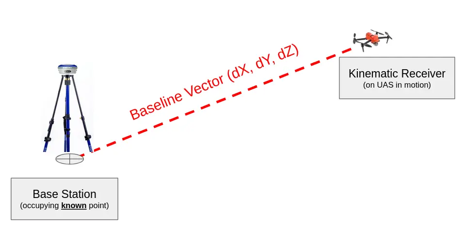
Here is how it works: The base station is placed on a known location and continuously transmits correction data to the drone in real-time. It’s important to note that “a known location” means a point where the 3D coordinates are known, for example an NGS monument, or a previously established control point. There are quite a few people out there that think that they can set their base station out anywhere and send RTK corrections to the drone and still get high quality data, but this assumption is incorrect. Why? Both RTK and PPK solve for the baseline vector between the base station and the kinematic receiver on the UAS (kinematic means “in motion”). If you don’t know the location of the base station, you won’t know the correct location of the UAS while its in the air.

Setting up an RTK system is straightforward. First, place your base station on a stable, known location and ensure it has a clear view of the sky. Connect the base station to your drone controller, and you’re ready to start collecting highly accurate data.
With RTK systems, another option to enhance real-time accuracy is to use NTRIP (Networked Transport of RTCM via Internet Protocol). NTRIP allows your drone to connect to a network of continuously operating reference stations (CORS) over the internet, eliminating the need to set up a physical base station. By utilizing a cellular connection or Wi-Fi, your drone can receive real-time correction data from these stations, enabling accuracy without the additional setup of your own base station. This is particularly useful for projects where mobility is key, or when operating over a wide area where setting up a local base station would be impractical.
NTRIP is widely used across the United States, but availability varies by state. Many states, such as Ohio, California, Texas and Florida offer robust CORS networks which provide reliable NTRIP services. Some of these networks are managed by state transportation departments or universities. Depending on the region, NTRIP services may be offered for free or come with a subscription fee.

Next, let’s talk about PPK. Unlike RTK, PPK doesn’t require real-time data transmission. Instead, it involves storing GNSS data recorded during the flight and processing it post-flight for the highest accuracy.
During a PPK flight, the drone records GNSS data, which is later combined with GNSS data from a stationary base station. These two datasets are processed together to create an optimized trajectory in order to geotag each image. PPK is well-suited for users who don’t mind “getting their hands dirty” as there are usually a few more steps involved when compared to RTK. PPK is reliable and robust against data loss.
Both RTK and PPK are ways of correcting the geolocation of individual photos to provide centimeter level accuracy. To use them, you will need a base station, a known location, and a modern GNSS reciever on the UAS.
The main benefit of PPK is that it allows you to conduct flights without maintaining a real-time connection between the drone and base station. This is ideal for situations where maintaining that connection is difficult, such as over long distances or in areas with interference.
While RTK provides real-time precision and can reduce the number of GCPs required, PPK offers flexibility in post-processing. Ultimately, both RTK and PPK improve the accuracy of your aerial photogrammetry projects, ensuring high-quality, precise maps, models and measurements.
Note: We do not recommend relying on RTK or PPK alone without any checkpoints on the ground to validate against. Additionally, with RTK/PPK tagged imagery, we recommend using a calibrated camera for consistency, when applicable. It is not required, but it enforces consistency across all your RTK datasets.
So, which should you choose - RTK or PPK? It really depends on your project’s needs. If you need real-time corrections and have a strong communication link between your base station and drone, RTK is an excellent choice. If you prefer post-flight processing and need more flexibility over long distances, PPK may be better suited for your workflow.

PixElement’s user interface is designed to automatically parse and interpret RTK/PPK data embedded within the EXIF metadata of your images, streamlining your workflow with minimal setup. For drones equipped with RTK, positional data is processed in real time and saved directly to each image file as it’s captured. When you load these images into PixElement, the software performs several actions:
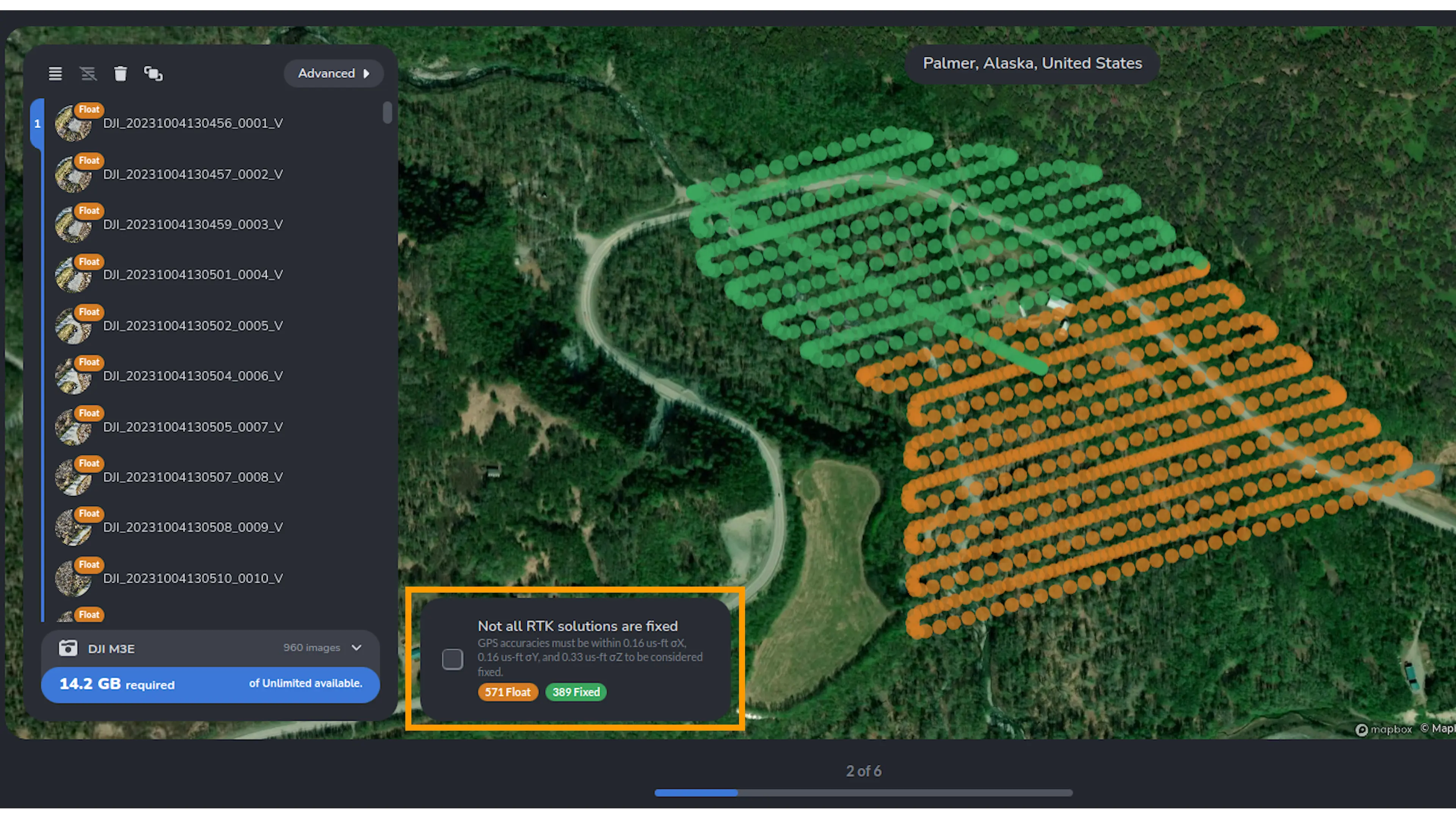
1. Automatic Detection and Categorization: PixElement reads the RTK/PPK metadata from each image and immediately categorizes each image as either “Fixed” or “Float” allowing users to see the quality of positioning accuracy at a glance. Fixed images are represented by green badges and meet high-accuracy standards, with a typical error margin of ±2 cm, making them ideal for precision projects like topographic surveys and construction monitoring. Float images, represented by orange badges, indicate slightly lower accuracy, with an error margin around ±200 cm, suitable for broader mapping projects where pinpoint accuracy isn’t essential.
2. Real-Time Data Validation: As PixElement parses each image, it runs a quick validation to confirm that positional data is complete and falls within expected accuracy thresholds. If anomalies are detected—such as missing or incomplete RTK/PPK data—PixElement flags these images, so users can make adjustments if needed before processing.
Pictured below is a project example where more than half of the images are considered “Float” and are hence highlighted in orange.
Note: If any of the images are classified as “Float”, a checkbox will appear that you must checkmark and agree to continue without all of the RTK solutions being “Fixed”.

3. Handling Mixed Solutions Seamlessly: PixElement is equipped to handle datasets containing both Fixed and Float solutions, which often occur due to changing GPS signal quality during a flight. The software’s processing engine integrates both types of data, combining them into a unified model without compromising overall accuracy, even when environmental factors cause temporary signal variations.
4. Consistent Feedback Through Visual Indicators: PixElement’s use of intuitive visual indicators—such as the green and orange badges—offers real-time feedback as you load and review images. This visual guidance helps users prioritize Fixed data and ensure they’re using the highest-quality inputs for projects requiring maximum precision.
By automatically parsing RTK/PPK data and providing visual indicators and precision insights, PixElement empowers users to optimize their data quality before final processing. This streamlined parsing capability ensures that users can focus on creating accurate models without needing to manually review or input positioning data.

To start a RTK or PPK project in the software, begin creating a project as you normally would.
1. Load Images and View RTK/PPK Classification:
Upon loading in your images, in the image list, you are able to view if your images are classified as “Fixed” or “Float”, indicating the quality of the RTK/PPK positioning accuracy for that image.
2. Access Detailed Accuracy Metrics:
You can hit the “Advanced” button on the top right of the image menu. Clicking this button expands the table, revealing individual accuracy values for each photo, including latitude, longitude, and altitude precision. This expanded view is especially useful for projects where specific image accuracy is critical, allowing you to identify any variations in positioning data across your dataset.


3. Configuring Reference Points:

After reviewing the images and classifications, proceed to the next menu to add your reference points file, if you have one. In the Select Reference Points configuration, you’ll be prompted to upload this file to set your project’s ground reference. Once your reference point file is added, select the appropriate Reference Point Coordinate System to match your project’s georeferencing needs. Choosing the correct coordinate system is vital for aligning your dataset accurately within your map or model’s coordinate framework. With the reference points configured, PixElement is now prepared to use these as control points for accurate geospatial alignment during processing.
If your project did not have any ground control points/reference points, please continue to process, but indicate that you would like to pause processing to add tiepoints later. Please see our tutorial on tiepoints here: Creating Manual Tiepoints Tutorial
5. Proceed with Control Point Registrations and Project Processing:
Continue to the Reference Point Registration process as you normally would. PixElement will utilize your RTK/PPK data and reference files to achieve optimal positioning accuracy, enabling you to process your project to completion with confidence in the precision of your final model.

In RTK/PPK aerial photogrammetry, a variety of file types are essential for managing positioning and control data. Here’s a brief overview of the most commonly used files:
- Coordinate Files (e.g., .txt, .csv, .crd): Store the precise locations of Ground Control Points (GCPs), which are essential for accurate georeferencing and ensuring positional integrity within your model.
- POS Files: Capture the exact position of the drone or survey equipment at the moment of data collection, directly correlating to each captured image’s location.
- OBS and RINEX (.rnx) Files: Contain raw GNSS (Global Navigation Satellite System) data, used in PPK workflows for post-processing corrections.
- KML and Shapefiles (.shp): Provide a visual overlay of GCPs or flight paths in GIS software, offering a spatial reference for quality control and data visualization.
Each of these files plays a crucial role in ensuring that your photogrammetry project meets high standards of precision and accuracy.
Conclusion:
Both RTK and PPK are powerful tools for enhancing the accuracy of aerial photogrammetry projects, allowing you to achieve centimeter-level precision in your maps, models, and measurements. By reducing the reliance on ground control points, these technologies streamline data collection and provide a more efficient, cost-effective mapping solution for various project needs. RTK’s real-time corrections make it ideal for applications requiring immediate accuracy, while PPK’s post-processed approach offers flexibility in environments where maintaining a real-time connection is challenging.
PixElement further simplifies this process by automatically parsing RTK/PPK data embedded in your images, categorizing each image by accuracy, and allowing users to see the quality of positioning at a glance. With intuitive visual indicators, mixed-solution handling, and precision feedback, PixElement empowers users to optimize geospatial data seamlessly.
Whether your project requires RTK or PPK, both methods help ensure high-quality results. The combination of RTK/PPK capabilities with PixElement’s user interface enables professionals to tackle diverse mapping challenges, from construction to environmental monitoring, with confidence and precision.