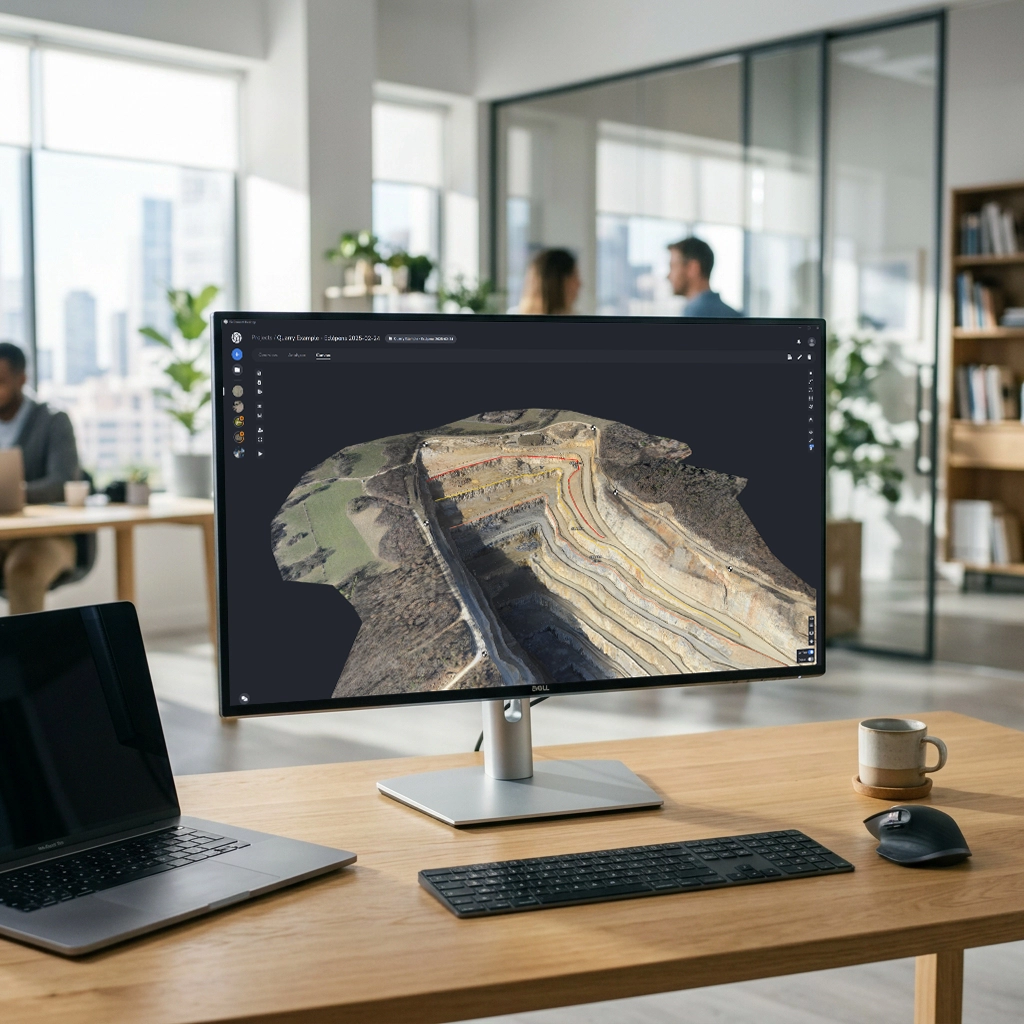
Learn about the new PixElement Desktop for Windows

Packages

PixElement Desktop offers a Basic package and an Advanced package. Download and start a free 14 day trial, or purchase a license today!

Basic

  • Process your imagery datasets.
  • Configure reference points.
  • Preview output products.
  • Export your dense point cloud, digital elevation model, surface model, orthomosaic, and processing reports.
  • One year of maintenance which provides access to software updates, a $350 value.

$3,500
with $350 annual maintenance fee after the first year

Advanced

  • Process your imagery datasets.
  • Configure reference points.
  • Preview output products.
  • Export your dense point cloud, digital elevation model, surface model, orthomosaic, and processing reports.
  • One year of maintenance which provides access to software updates, a $350 value.
  • Process LiDAR datasets with LiDAR input processing.
  • Access the Canvas, our integrated 3D Drafting and GIS software.
    • Draft linework.
    • Generate contours.
    • Measure volumes.
    • Compare timelines.
    • and much more! Try the Canvas here!

$5,500
with $350 annual maintenance fee after the first year

Want to try it first?

Download now to start a free trial.

Product Features

Map

Extract

Deliver

Support

Features
Drone Imagery (Nadir/Oblique)
Aircraft Imagery
LiDAR
Camera Models
Integration of RTK data from exif metatags
Rapid Processing Option
LiDAR + Photogrammetric Deliverables
 
Benefits
Use nadir and oblique imagery captured from drones for comprehensive coverage to generate high resolution 3D models.
Capture imagery from aircraft for large-scale mapping projects.
Import and process LiDAR point cloud data for precise terrain modeling and analysis.
We support thousands of different camera types and are adding more by the day.
Seamlessly integrate RTK information from image metatags or external files for enhanced georeferencing accuracy.
Looking to get rapid results in the field? Find our rapid option and get results back in minutes, not hours.
Create true color point clouds, textured 3D meshes, and orthoimages by integrating imagery with your LiDAR data.
Features
Orthoimage
Point Cloud
Textured 3D Mesh
Digital Elevation Model
Generate bare earth TINs
Edit break lines on TINs
Generate Contours
Coordinate Systems
Digital Field Survey
Layer Manager
2D Drapes/Overlays
Project Timeline
DXF + LandXML Support
Stereo Photogrammetry
Reference Point Manager
 
Benefits
Generate orthorectified imagery for accurate map creation and analysis. Correct image distortions caused by building relief and camera angles for true orthomosaics.
Extract dense point cloud data from aerial imagery and LiDAR scans.*
Visualize reality on your jobsite with detailed textured 3D mesh models.
Generate high resolution Digital Elevation Models (DEMs).
Create bare earth TINs for precise terrain analysis.
Add, modify or delete breaklines on your TINs to better represent specific terrain features.
Create contour lines from elevation data to produce maps for surveying, engineering and environmental analysis.
Select from thousands of coordinate systems throughout the world, or use a localized system customized for your site.
Import ground shots from your GNSS or total station into the project for field check verification and editing.
Manage your different drawing features and codes under different layers and preserve your existing workflows for surveying.
Overlay multiple project imagery datasets in 2D viewer to visualize the progression of a project site and mitigate future problems.
View different dates of your project side by side with our Timeline viewer.
Import your field linework or export your digital linework while preserving lines, curves, arcs, etc. We support and advocate for open land design formats.
Measure anything that is visible in imagery with our stereo photogrammetric measurement interface.
Use Ground Control Points, Checkpoints or Manual Tiepoints for your aerotriangulation.
* Dense point clouds using LiDAR scans only available with Desktop Advanced
Features
Multiple Export Formats
Reports & Documentation
 
Benefits
Export your data and models in a variety of formats (obj, las, tif, tfw, jpg, jgw). Ensure compatibility with industry-standard software and GIS platforms.
Generate detailed Bundle Adjustment and Project Reports summarizing project findings, annotations and methodologies via PDF.
Features
Phone
Chat
Email
Language Support
Education
 
Benefits
Talk with a real person! No elevator music or automated recordings. Get help from real humans.
Directly chat with product support specialists and product developers.
Have a question outside of working hours or on the weekend? Send us an email and we will follow up with you.
We support Spanish, Portuguese, German, French, Hungarian, Polish and Hindi, and are working to add more.
Access education resources, including tutorials and documentation empowering users to enhance their skills and proficiency leading to improved productivity and project outcomes.
* Rows highlighted in blue are only available in Desktop Advanced.

Hardware Requirements

To process your projects locally, PixElement Desktop requires Windows 10 or 11 with a lot of computing power, RAM, and storage. These are our mininum and recommended specs for your computer.
Hardware Minimum Recommended
CPU Intel I7 / AMD Ryzen 7 Intel I9 14 gen / AMD Ryzen 9
CPU Cores 8 / 8 24 / 16
CPU Threads 16 / 16 32 / 32
RAM 32 GB 64 GB or more
SSD MVMe 1 TB free 4 TB or more free
Graphics Card Nvidia GeForce * Nvidia GeForce *
* Or equivalent. The software will use both the GPU and Adaptor RAM of the card.
Make sure to set your Power Mode to Best performance under your computer's System Settings to get faster processing times.
No internet connection is required to process your datasets, making it easy to process while in the field. However, an internet connection is required for your initial license activation, as well as every 90 days.