Understanding Coordinate Systems & GPS in Photogrammetry
Collecting accurate data is the backbone of successful photogrammetry projects. At PixElement, our mission is to provide advanced tools that make mapping and modeling more precise and efficient. One key aspect of achieving this precision is understanding and utilizing coordinate systems effectively. In this blog post, we will break down the essentials of coordinate systems, and why they matter.
Basics of Coordinate Systems
Coordinate systems allow us to pinpoint certain locations on the Earth. They are crucial in mapping and photogrammetry because they provide a standard way to define positions and ensure that data from different sources can be accurately aligned and integrated.
There are many different types of coordinate systems, each suited for different applications and scales. Upon uploading your imagery data and control points when creating a project, PixElement will look at the metadata of your photos and/or control points and automatically determine which coordinate system is being used.
With mapping and photogrammetry, you will primarily see/use Geodetic Coordinate Systems (GCS), Local Coordinate Systems, and State Plane Coordinate Systems when you’re in the United States.
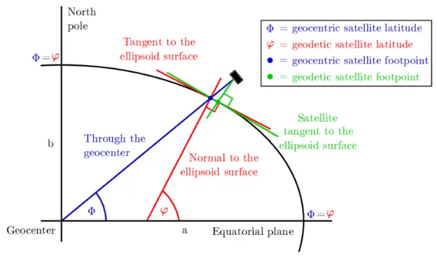
Diagram showing difference between geodetic and geocentric coordinate systems.
Geodetic Coordinate Systems (GCS)
Global Navigation Satellite Systems (GNSS) use geodetic coordinates. Geodetic coordinate systems use a three-dimensional reference ellipsoid of the earth to define locations using latitude, longitude and height (x,y,z axes). Geodetic latitude is defined as the angle between the equatorial plane and the surface normal at a point on the ellipsoid, whereas geocentric latitude is defined as the angle between the equatorial plane and a radial line connecting the centre of the ellipsoid to a point on the surface (see figure). Over the years, scientists have created multiple ellipsoidal models of the Earth. The World Geodetic System 1985 (WGS84) is the most common GCS datum used by GPS satellites. However, there are many other regional and local datums used that are tailored to specific areas to provide more accurate positioning within those regions.
State Plane Coordinate Systems (SPCS)
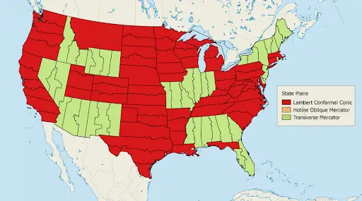
State Plane Coordinate Systems are a set of standardized local coordinate systems used within the United States. Each state is divided into one or more zones, with each zone having its own coordinate system to ensure minimal distortion within that zone. SPCS use either the Transverse Mercator or Lambert Conformal Conic projections, depending on the shape and orientation of the state or zone. There are 124 zones total within the United States, each with a projection of its own. Ultimately, distortion is kept to a minimum due to the smaller zone sizes.
Local Coordinate Systems (LCS)
Local Coordinate Systems are tailored for specific project sites or regions, providing high precision and accuracy over small areas. These systems are typically customized to meet the precise needs of a particular project, such as a construction site, a small survey area, or an engineering project. LCSs simplify the Earth’s surface to a flat plane to minimize distortion and maximize accuracy for the area in question. Because they are tailored to a specific location, they provide high precision over short distances but are not standardized across large regions.
Reasons for Using Local Coordinates
Opting for local coordinates can be advantageous for several reasons:
- Ground Coordinates: Operating in ground coordinates is more beneficial for your site than using grid coordinates.
- Independence from Global Systems: You prefer your site’s coordinate system to be independent of dynamic global geodetic systems, such as WGS84, NAD83, or GDA94, which are frequently updated.
- Reduced Distortion: The specific region and size of your site make using a standard ellipsoid impractical due to high distortion in survey measurements.
- Simplified Measurements: You desire smaller magnitudes for your site coordinates compared to state plane or national grid systems, which can extend into the millions of meters or feet, complicating work.
For example, imagine a large construction site where precise measurements are crucial for building structures. The project managers would establish a ground Local Coordinate System specifically for the site. They would set up a grid with a defined origin point (0,0) at a particular corner of the site instead of using a national or global datum. The coordinates within this system are used to accurately locate and construct the foundations, walls and other features of the buildings.
Understanding GPS Interconnectivity via Trilateration
GPS satellites orbit the earth and continuously transmit signals that include the satellite’s location and the exact time the signal was sent. The system’s GPS receiver captures these signals and uses the time delay between sending and receiving to calculate the distance to each satellite. This is done between multiple satellites, and the precise location of the system is calculated using this trilateration. When the system’s GPS receiver calculates distance to at least three satellites, it can determine its position.
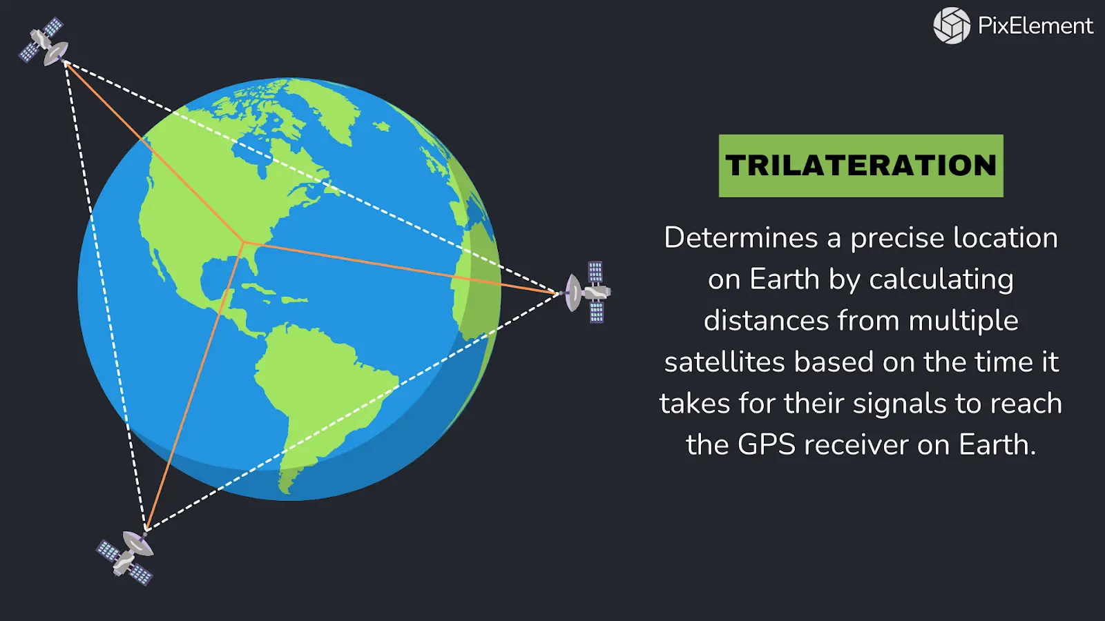
The distances to the satellites define spheres around each satellite. The system’s position is where these spheres intersect. Typically, a fourth satellite is used to refine the position further and correct any clock errors in the GPS receiver. This process allows the system to pinpoint its location in three dimensions: latitude, longitude, and altitude. Factors like signal reflections, atmospheric conditions and clock discrepancies can introduce errors, but specific algorithms are used to mitigate these issues and ensure accurate positioning.
So when you fly your drone, the drone connects to many different satellites, some that are right above, and others that are at lower angles closer to the horizon. By connecting to these satellites, it can determine its exact position and altitude via barometric pressure, ensuring accurate navigation and data collection.