How High Should You Fly for Aerial Photogrammetry?
In aerial photogrammetry, determining the optimal altitude is all about finding the delicate balance between precision and efficiency. With advancements in technology and an increasing demand for high-quality data, the question arises: How high should you fly?
Flying drones for aerial photogrammetry is not just a technical endeavor; it’s an art form, as Dr. Benjamin Vander Jagt, co-founder and President of PixElement, eloquently puts it. The journey involves investing time into mastering both the science and the craft. So, let’s explore the importance and differing factors of flying altitudes in aerial photogrammetry.
The Impact of Flight Altitude
Flight altitude is a crucial factor that influences various aspects of your data capture and processing. Here’s a glimpse into its multifaceted impacts:
-
Image Resolution and Accuracy
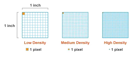
When flying at different altitudes, the resolution of your imagery varies. As the altitude increases, the Ground Sampling Distance (GSD) on the ground increases as well. This correlation between flying height and GSD is pivotal in determining the resolution and overall quality of your imagery. Additionally, higher altitudes can result in better coverage per frame, potentially reducing the number of images needed to cover a given area, giving the pilot less time out in the field.
-
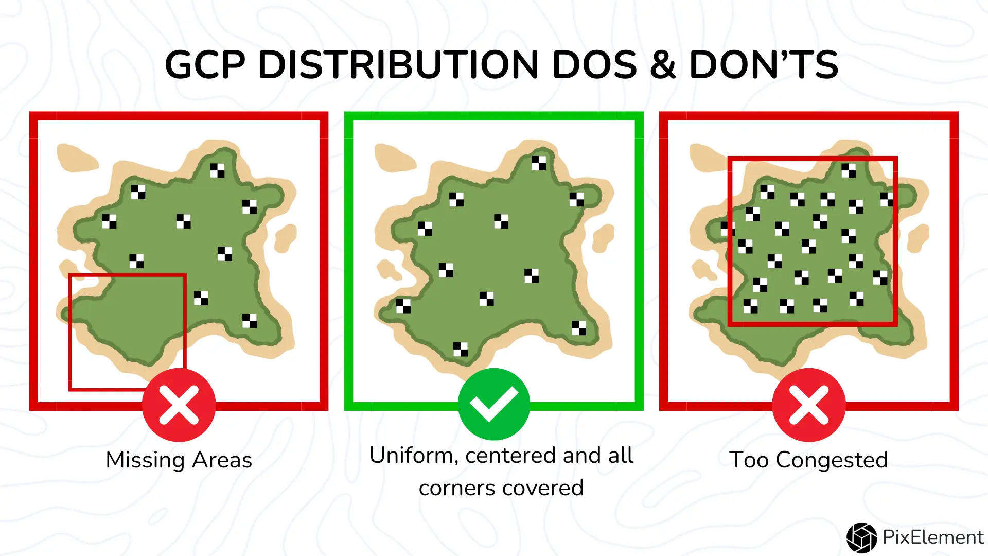
Ground Control Points (GCPs) & Number of Cameras Reconstructed
The number and distribution of GCPs plays a crucial role in ensuring the accuracy of photogrammetric outputs. While higher altitude flying may necessitate fewer GCPs, each GCP carries more weight in anchoring the photo in post-processing reconstruction. So if you have less photos, more distortion and error could occur in the final modeling. When setting GCPs, be sure to evenly distribute them throughout the site you are mapping.
-
Camera Technology and Data Processing
More megapixels on your camera do not always translate to better quality data. Higher resolution imagery can lead to longer processing times and larger datasets, posing challenges in data management and workflow efficiency. Therefore it is essential to strike a balance between resolution and processing overheads, optimizing data quality without compromising operational efficiency.
It is a very common mistake that users are flying their projects too low. The flight ceiling for flying a drone is 400 feet above ground level and very few individuals are flying their projects this high even though they are increasingly using drones with larger camera sensors - which increases ground sampling distances significantly.
-
Terrain Considerations
Flying height relative to ground features like buildings, trees and sloping terrain can significantly impact data capture and reconstruction. Flying at higher altitudes can mitigate issues such as missing areas in the dataset and reduce the impact of terrain features on reconstruction quality.
Finding the Sweet Spot
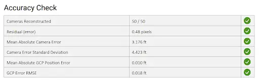
So, where does the sweet spot lie amidst these considerations? The answer is not one-size-fits-all; rather, it depends on the specific requirements of your project. The ultimate goal of the pilot in command is to make sure that all parameters are sufficient to create a good model. With PixElement, you can view these parameters in the Bundle Adjustment Report under Accuracy Check. If you would like a deeper dive into the Bundle Adjustment Report, please check out our tutorial video here: https://www.youtube.com/watch?v=8h8oulBxS4E
Conclusion
When navigating the complexities of determining the optimal flying altitude for aerial photogrammetry, it’s essential to adhere to several key principles. First and foremost, adopt a purpose-driven approach to flight planning, allowing the specific requirements of your project to dictate the optimal altitude. Whether you’re engaging in precision agriculture, stockpile measurement, infrastructure inspection, or environmental monitoring, tailor your approach accordingly to ensure alignment with project objectives. Additionally, strike a delicate balance between resolution and efficiency, opting for a flying height that maximizes data quality while minimizing processing overheads and data management complexities. Embrace a culture of experimentation and adaptation, testing various flying heights to assess their impact on data quality, processing time, and overall project outcomes. Finally, leverage advancements in drone technology, such as RTK/PPK capabilities, to enhance accuracy and streamline data collection processes, thereby unlocking new possibilities in aerial photogrammetry. By understanding the interplay between flying height, data quality and operation efficiency, you can navigate the skies with confidence, achieving optimal outcomes with every project.